Daluntouweishan Hiking Trail (Wuzhi Mountains)
五指山系 大崙頭尾山親山步道· Hiking trail
About
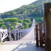
Daluntoushan and Dalunweishan lie on the main ridge of the Wuzhi Mountains that extends west, running from north-east to south-west. Dalunweishan is 451 m above sea level, with large rocks lined up to form its peak. Daluntoushan, at 475 m, is the highest mountain in the Neihu area, and its summit platform has a wide view. The two mountains stand side by side and are an important landmark of the Zhongyang community in Shilin. A fault runs through Dalunweishan, so the terrain is steep, and as it lies in a protected water-source area there has been little development and its natural vegetation is well preserved. From the Zhongyang community trailhead you first walk a wide, flat gravel path lined with tall shady trees. The summit has a viewing platform looking towards Waishuangxi and Yangmingshan. Heading on towards Daluntoushan, Dalun Lake halfway up the slope has green water that reflects the hills. Along Bishan Road towards Daluntoushan, silvergrass sways in the autumn wind. On the north side of the hills a nature trail connects with the Wanxi industrial road; it runs hidden in the forest, with the woods of Neishuangxi Forest Nature Park alongside all the way. The path into the forest is a wide boardwalk of wooden railway sleepers. It is raised among the trees for its whole length, which avoids damage to rocks and plants on the ground and makes it easy to observe nature, and interpretive signs every short distance explain the geology and ecology. Here and there trees seem to 'burst out' of the boardwalk: they were growing there first, and the boardwalk was built around them, so the forest keeps its natural character while walkers have a convenient path. Because the forest's 'original inhabitants' keep their living space, insects and birds are heard constantly and squirrels are often seen leaping through the trees. The path climbs all the way, but the wildlife makes people slow down, stop to look or check the signs. For a rest, there are sleeper platforms by the path round many bends, for views and for sitting. The boardwalk offers about 1 km of natural wooden sleepers close to the city, and many experienced hikers walk it barefoot. From the trail entrance towards Dalunweishan you first meet a wide, flat stretch of gravel. Most other sections are stone steps, but dense forest continues throughout. The forest along this green corridor is mature and varied because the trail passes through the secluded, almost undeveloped western foothills of Daluntoushan. Dalunweishan has no primary forest, but its steep terrain made development difficult, and as it lies in a water-source area there has been less human disturbance, so its natural ecology is relatively well preserved. On the windward side between Daluntoushan and Dalunweishan, strong winds all year keep the trees noticeably low, forming a 'wind-sheared dwarf forest' of plants such as 紅楠, 森氏楊桐, 大頭茶 and 小葉赤楠. The cooling effect of the north-east monsoon lets plants that normally grow in mid-elevation environments of around 2,000 m survive here at just over 400 m, an unusual case of plant 'northward descent'. For example, deciduous plants of temperate regions such as 野鴨椿 and 雷公藤 also grow well here. The summit area has warm-temperate broadleaf forest, and the warmer valleys have buttress roots and trunk-borne flowers, features common in the tropics. Together with the original subtropical broadleaf ecosystem, tropical, subtropical and warm-temperate zones are concentrated in one place, forming an unusual and rich 'compressed' ecosystem. Daluntoushan is the highest mountain in Neihu District. Its summit platform has a wide view, with viewpoints on both sides of the open area. Close by on the left are Dalunweishan and Shitoushan; the small hill below on the right is Yuanzaishan. From here Dalunweishan looks especially imposing, unlike a hill of only just over 400 m. To the north, the Datun Mountains that shield northern Taipei and the volcanic shape of Shamaoshan are clearly visible; across the valley, Pingdeng Village sits on a terrace formed by lava flows from volcanic eruptions. At the other end, the Wuzhi Mountains and the lakes around Neihu's Dahu Park can be seen, and beyond the Keelung River the hills stretch from Xizhi to Pingxi, Shiding and Keelung. Near the summit of Dalunweishan there are many rest pavilions and viewpoints. The summit platform is very wide, with a simple viewing deck looking towards Waishuangxi and Yangmingshan National Park. Small steps lead down to another platform beside a nearby hut with a shelter, with a different view. A large lookout beside the trail near the summit has a 360-degree view of the rolling Wuzhi Mountains and the peaks towards Xizhi.
Translated and shortened by DealTaipei from Taiwan's national tourism database. Sources are on the terms page.
Getting there

Good to know


Sources and photo credits are on the terms page.