Zhongyishan Hiking Trail (Datun Mountains)
大屯山系 忠義山親山步道· Hiking trail
About
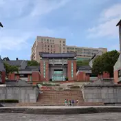
The trail lies on the hill behind the Taipei University of the Arts and is also called Xiao Balifenshan. Its main feature is that about 90 per cent of it is shaded by trees, so the stone steps stay cool even on hot summer days.
Read more
The trail is demanding: it is almost entirely stone steps, with a long, steep climb before the summit that tests leg strength and stamina. Keep your breathing steady on the climb or you will soon be out of breath. For a rest, in the first half you can detour to the pavilion behind Xingtian Temple; in the second half you can stop on the wider stretches of steps with railings. When you see green railings, the broad summit platform is not far off. At the top there are benches and a pebble path for stimulating circulation. The summit is regarded as the best place to see the shape of Guanyin Mountain, the Tamsui River is also in view, and little egrets are sometimes seen on the flat top. The way down is narrow and quiet, with denser shade. Following ropes along the way, you reach another viewpoint facing Guanyin Mountain and the Tamsui River. Near the end of the trail, the Guandu Plain, the MRT Beitou depot and the incinerator tower come into view.
Translated and shortened by DealTaipei from Taiwan's national tourism database. Sources are on the terms page.
Facts and sources
- Names
- EN Zhongyishan Hiking Trail (Datun Mountains)中文 大屯山系 忠義山親山步道한국어 중이산 등산로 Chinese from the listing; English by DealTaipei
- District
- Beitou District · 北投區 Tourism Administration listing, updated 2026-05-20
- Opening hours
- Not in the listing Tourism Administration listing, read 2026-09-30
- Phone
- (02)27593001 Tourism Administration listing. May be Chinese only
- Data
- /api/sight/zhongyishan-hiking-trail-datun-mountains.json The same facts as JSON, for apps and AI agents
Getting there


Sources and photo credits are on the terms page.